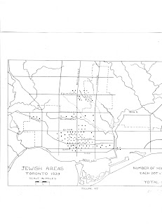
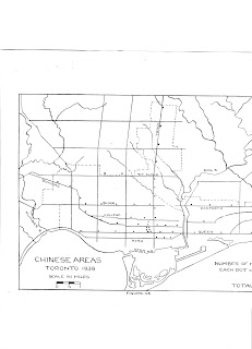
Before World War I, an area near City Hall known as the Ward (bordered by Yonge St. and University Ave., College and Queen Sts.) was home to most of the city's Jews and Italians. By the 1930s, however, most of the city's ethnic communities had moved to the west-central area of the city, in wards 4 and 5, between University Ave. and Dovercourt Rd. south of Bloor St.
In a 1941 MA thesis Nadine Hooper ("Toronto: A Study in Urban Geography") mapped the residential concentrations of various ethnic groups in the city in 1939, based on samples from community directories. This gives us the general picture of Toronto's ethnic map on the eve of World War II. I share here her maps for the Jewish, Italian, Ukrainian and Chinese communities.
Italians were more spread out. However Little Italy along College St. was already well established and the main residential concentration was located south of College between Bathurst and Dovercourt Rd. Other Italians lived in the industrial northwest area, particularly near Dufferin St. and Davenport Rd. This would serve as the impetus for the northwest movement of the Italian community in the postwar years.
Ukrainians, as well as Poles, were concentrated in the Bathurst-Queen area. Many lived and worked in the Niagara St. industrial district south of Queen. Both of these communities would follow Queen St. to the High Park area after WWII.
As Jews and Italians moved westward, the Ward became the city's Chinatown. However the majority of the city's Chinese residents were scattered among the main retail arteries, living above laundries, restaurants and other businesses. After the demolition of old Chinatown in the 1960s to build the new City Hall, the present day Chinatown developed in the formerly Jewish Spadina area.


I didn't realize the Ukrainians started out so close to downtown, are there any signs left of their former presence? And looks like the Italians were initially centred more around Dundas than College?
ReplyDeleteUkrainians and Poles started in the Bathurst-Queen area (Nadine Hooper only mapped the Ukrainians but the Poles lived in basically the same area) and then moved westward towards High Park in the postwar years. There is some signs of their former presence (a Ukrainian church at Queen and Bellwoods was just sold and there's another old Ukrainian church on Niagara St. I believe). Toronto's oldest Polish church is still in the area, located on Denison St. just north of Queen.
DeleteAs for the Italians, Little Italy developed around College and Manning around WWI, with a residential concentration radiating south of College.
This comment has been removed by the author.
ReplyDelete